Chapter 8, Part 2: "Sezel at Taral,"
from "Legacy of the Chief "
It has been said that the sleep-doctor’s magic was so powerful that, when in his presence, even the unbelievers could sometimes see the images of the spirits who were in the constant company of the great chief. As far as the white men of the day were concerned, Nicolai was the true chief of the entire Ahtna people. No one ever again was able to fill the role which was Nicolai’s alone. His word was final, even for those who failed to properly recognize his power. We had good reason to respect the tyone. When Nicolai spoke, his words had the unnerving effect of becoming predictions or warnings of what lay ahead. He was the traditional chief in 1910, having long since given up the demands of the duties of a real chief when it was clear that the white men were about to take over our land. Just as Hanagita had allowed Nicolai to take over the title of chief, Nicolai passed his torch over to his son Goodlataw. The traditional chief is an honorary position. In his ceremonial role Nicolai would politely listen to anyone who took the time and the trouble to seek him out. He was much more likely to be found at the deserted encampment of Taral than at the village of Chittyna.
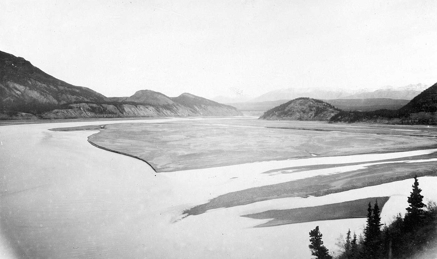
Taral was across the river from the railroad construction town of Chitina. As a raven would fly it was close, but access was difficult because the confluence of the Chitina and Copper Rivers made it so. Boats and rafts were rare in those days. Doc Billum had two of them that he kept near Tonslahti. Taral was just downstream from there. The Copper was wide and treacherous at this point. It was an area of ceaseless winds and gusts which carried massive amounts of blasting sand and other glacial dust which were carried off of the treeless banks lining both sides of the river in places. It blew so hard that the sand frequently obscured visibility, rendering river passage extremely hazardous. We have watched the winds carry the yellowish, finely-grained glacial and volcanic dust hundreds of feet into the air, rising well above railroad grade. The riverbed included many constantly shifting sandbars, but only one main channel which also tended to shift. If the hazardous part of the river at the confluence was not skillfully negotiated, one was likely to inadvertently enter the whirlpool area caused by the meeting of the two massive rivers. Our boats were too small to avoid being pulled under if this were to occur. It was always best to stay near the west bank, which followed the steep cliffs that were blessedly covered by spruce all the way to river level, instead of being covered by the light sand that could blow back in our faces.
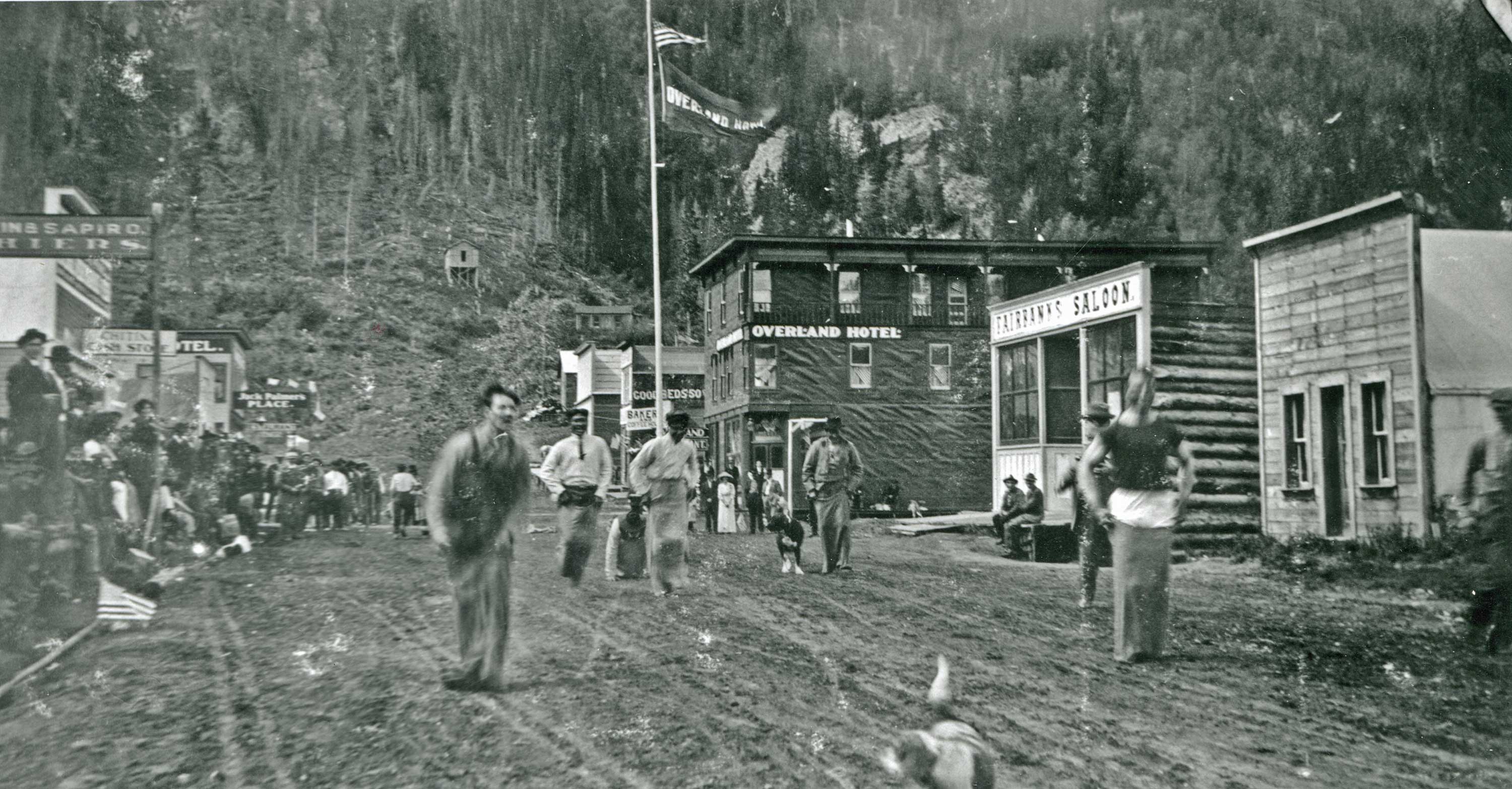
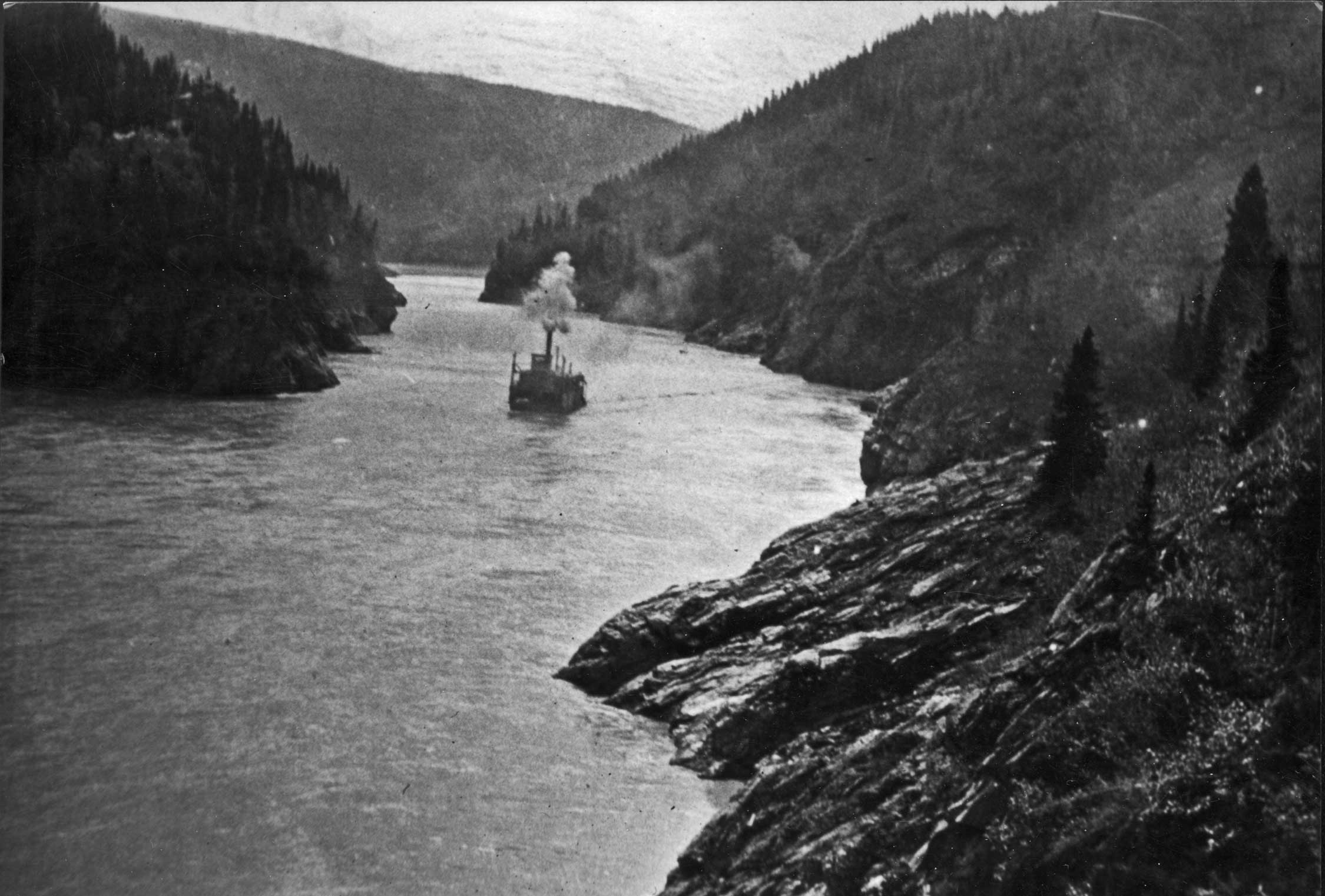
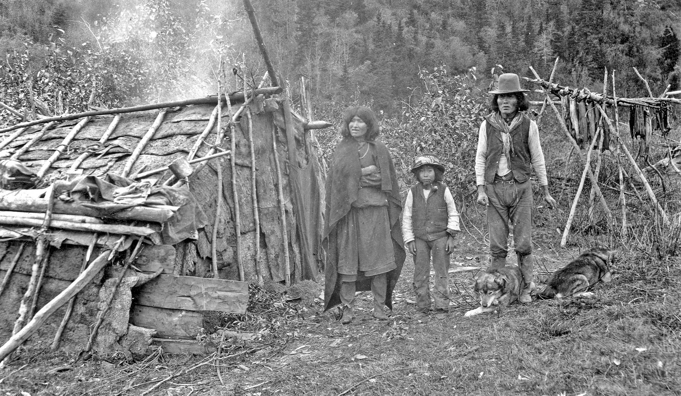
The river funneled into the head of Clay Woods Canyon at the point where Taral Creek entered the Copper River. The grassy and sandy promontory at Taral Creek gently rose to a low-lying hills where the primitive structures of Taral have stood and been re-built for maybe a thousand years or even more. Since the chief’s death so many years ago, Taral has remained abandoned, its purposes having been served. It is no longer the lively summertime fish camp from which forgotten generations of our people would strike out into the rugged east country toward the vast upper lands of the mountain glaciers to hunt the great Dall sheep and other animals which frequented the high grounds. Although our Ahtna people were nomads, Taral came as close to a permanent settlement as any. It was Taral which Lieutenant Allen first encountered, no doubt to his great relief, upon successfully making his way up the Copper River in those early years of the great western incursion. Nicolai’s people saved Lieutenant Allen and his small party from exposure and near-starvation, though that’s not exactly the official story which has been passed down as history. In the American west, it was invariably the coming of the U.S. Army cavalry which brought an end to our Indian brothers’ way of life. First would come the gold seekers, then the fence builders. With the ranchers came the ket-chee ten-eh thloo-da-kee --the iron trail machine. As was always the case, the cavalry would enter the scene to save those miners and other settlers and their iron horses from our supposedly hostile Indian brothers. In reality, those white people were on an unstoppable mission to claim our traditional grounds for their own purposes, even if it meant driving out or killing the Natives who had lived there from times long forgotten. It was American manifest destiny. It was we who saved the cavalry in the person of Lt. Henry Allen. The U.S. Army did not end our way of life here. That role fell to the railroad which followed a quarter century later. Nicolai lived to see the first of those machines on iron rails. He was the only one to proclaim that with the coming of the railroad, our old ways would be over. He insisted that we would have to adapt to the new ways while keeping our Indian souls intact by maintaining the best of our traditions, especially the potlatch--and by sticking together. We would be lost if we did not act as one. Nicolai developed a strong but nearly invisible relationship with the Great Man, Stephen Birch. It was Birch who was behind the mines which the railway served. Only Stephen Birch was in a position to grant the tyone what he sought. Nicolai wanted nothing less than the continued existence of our people on our own lands living by our traditional ways, with the help of the railroad. The intrusion of the white man with his great iron machines marked not so much an ending as the beginning of a whole new and very strange world to which we would either adapt or we would die. Many among our number died. It was as simple as that. From that inescapable fact of life there could be no argument. It simply was. My grandfather feared that it was he who had opened the way to these “white devil spirits,” as he called them, first by saving that army scouting party and then, even worse, by revealing the source of the tsedi to the McClellan party in the year I was born. When the tyone first recognized the amount of excitement which the Nicolai Prospect had generated, he feared a stampede like the gold rushes of the old west which drove our Indian brothers from their ancestral lands--those who had already survived the diseases, the alcohol, and the outright slaughters. Then came the discovery of the enormously rich Bonanza copper outcropping. Nicolai realized to his horror that the door had been opened wide for a massive encroachment of the westerners into his beloved land. Like the mythical Pandora’s box, it was no longer possible to close that door. Nicolai’s role as tyone ended with the incursions. He seemed powerless in the face of the unstoppable forces best expressed with the coming of great iron machines. It was in 1900 that the old chief retreated like a hermit to the nearly abandoned site of Taral to live out the rest of his days in apparent despondency. Or so it appeared. Nicolai had not been the chief our Saghani utsuuy clan for so many years because of his own self doubting. It was not in his nature to stew in self-loathing. In the comfortable perspective of all these years since my brothers Michael and Charlie and I sat at that fire in the old camp, I have come to believe that Nicolai was the right leader for us at the most critical moment. He comprehended the situation only too well and found within himself the ultimate Native solution. It was a very brief, yet hot, dusty summer which had already slipped into an early fall. The leaves turned early. Snow appeared on the upper reaches of the foothills surrounding Chittyna. I have always preferred the old spelling of Chittyna, which was quickly altered to Chitina because someone, probably that old unrepenting, wholly unreasonable redneck, Otto Adrian Nelson, thought the spelling looked too Indian. Even though that original spelling is now largely forgotten, I still use it to differentiate the Indian village from the white man’s railroad town of Chitina.  The mature town of Chitina & Town Lake in the late 1930s Chitina began as a railroad junction. The trestle crossing upriver marked the beginning of the branch line that terminated at the Bonanza mine site. The railroad surveyors picked the location of the town site well. Chitina was just downriver from an easy crossing point to the east bank. The site is partly protected from the winds and the extreme winter cold of the river banks 100 feet below, due to tall rocky hills surrounding the town in all directions. Chitina sat in a natural bowl, though there were outlets to the south and the west. The wide, circular shore of Town Lake, originally known as Trout Lake before the town’s open sewers ruined it, proved ideal as a natural track-turning circle, enabling the trains to reverse directions at Chitina, returning to either Kennecott or Cordova as the circumstances required. As it turned out, the railroad company found it could run two separate trains on the same single line track because of the large turn-around at Chitina. The Chitina Local worked the line from Chitina to Kennecott and return, while the Mainline or Cordova Local ran larger consists from Cordova to Chitina. The railroad town of Chitina could not be seen from Taral. Nor could it be seen from any point along the river because it is hidden behind a tall mound of shale-like rock towering hundreds of feet above Chitina. known as Spirit Rock. Thus the natural bowl which was Chitina was bounded by the 600 foot-tall rock mound and also by the steeply rising foothills which extended into the Chugach Range, whose 5,000-plus foot summits were frequented only by sheep and mountain goats. Even though the view of the town was blocked by Spirit Rock, the glow from all that construction activity could be seen downriver as far as Taral. Chitina the construction town was about to become Chitina the railroad junction. The place was temporarily populated by railroad construction workers probably numbering into the thousands. Many of those men stayed at the canvas tent town, just down river from the trestle crossing. The two 120-foot river steamers were moored at the landing by the trestle crossing the night we were at Taral. The Tonsina and the Nizina each held a cargo of timbers and rails picked up at Abercrombie Rapids Landing at CRNW mile 55. The large, temporary construction tent-town on the river banks near the crossing took up the space we customarily used for netting fish. After the camps moved on up the rails, we placed the first of our new Columbia River style fish wheels there. Since then, we have always had fish wheels at the site.
On this night the third steamer, the 110-foot Chittyna, had pulled up along a sand bar near a place later known as Haley Creek, just below Clay Woods Canyon. This was a wide sandbar that was the location of a second large construction camp. The relentlessly approaching steel rails ended near this camp on this early September evening. The constant blasting in the canyon was a source of irritation to Grandfather, but it was finally over for the night and all was relatively quiet. Grandfather believed that we had no choice but to adapt in our own unique way to the new world of the white man. He saw Chitina as one of our main spiritual focal points which we Ahtna people must ultimately reclaim as exclusively our own. For this reason, we have continued to bury our own in various places close to the old railroad town rather than in the more remote sites we deserted when the railroad came. When the first snow arrives, it initially reveals itself at the top of Spirit Mountain, which is a steep, distinctive peak standing in defiant magnificence several miles to the south of Taral. Spirit Mountain crowns a wild region along the east bank of the Copper which extends from the south bank of the Chitina River, through Taral and beyond to the Bremner River, just north of a massive ice field this side of the Chugach Range. The view across the river on the west bank centered on a steep ridge which towered well above the new Copper River and Northwestern Railway cut. The railroad grade was about 100 feet above the river level and ran along a sheer cliff. The irregular cliffs above the rail bed shot in a swift vertical climb thousands of feet toward summits which only briefly in the summer were freed of their snow caps. Spruce followed these rugged slopes only a few hundred feet before giving way to alpine growth of low brush intermingled with low brush and brightly-colored flowers of the high meadows which existed among the steepest of precipices. Mostly, though, the scenery was dominated by bare, ruggedly eroded rocks which briefly altered their angle of ascent to gentler angles before resuming another steep climb approaching the highest summits about five miles from the western bank of the Copper River. The low foothills were sharply cut with deep ravines. These were usually choked with rapidly moving mountain streams emanating from the upper reaches of those lofty mountains of shale. The relative closeness of the tall foothills opposite Taral concealed the tallest of the peaks from view. Nevertheless, we could clearly see the beginnings of the snow caps on the closest of the high summits threatening to soon bring the full force of winter upon us that early September of 1910. The Copper River has always been the center of our existence. Even in the years when the hunting was not so productive, we could always count on the salmon from that river for our sustenance. The Copper River ran through eighty miles of a buffer area which all the Native groups respected as no-man’s land. Beyond that, it eventually led into the land of the Eyaks, the Chugach and the Tlingits--our traditional trading partners for as long as we have had tsedi to trade. Some of our own people are said to be from among the Tlingits, having given up their rich coastal way of life for our much more rugged and primitive interior lifestyle. The custom of the potlatch which we have long since adopted as our own probably came from our Tlingit brethren.  Eskilida Fish Camp across the Copper River from Taral --Candy Waugaman Collection Before the white man came, many fish camps existed along the east bank of the Copper. All that quickly changed after the turn of the century. Even Taral--the most famous of them all--would quickly be deserted. The government schools and the trading posts were all built on the west bank. This was only the beginning of the changes. Some of the Native fish camps on the west bank, including old man Eskilida’s place along a stream named after him at CNRW mile 127 existed when the railroad arrived. For every stream entering the Copper there would be a corresponding fish camp. Eskilida’s was the closest one to the new construction town of Chitina at CRNW mile 131 in 1910. Some of our ancestors were buried at CRNW Mile 127. The railroad survey went right through the burial grounds. This would later prove to be a source of major conflict between the railroad company and us. Chitina boasted the first of a small number of government schools which had been especially established for our people. All these schools were on the east bank of the Copper, from Chitina to Copper Center, to Gulkana and all the way up the river to Chistochina. The three of us boys would be returning to the government school soon. For the moment we would be able to experience this last glimpse of a rapidly fleeting summer before the full force of winter descended upon us. What a memorable occasion this was to become. The event was a pivotal moment for all three of us. We were about to hear Grandfather’s story of the beginning of humankind and of our great mountains as it was related within his own elaborate version of the Raven Story of Creation.
|
No comments:
Post a Comment